
I have been privileged enough to have several diverse research experiences. For a career, I want to work in geospatial analysis. I also have a strong interest in promoting education and geoscience to the masses. This research statement is a generic outline of the potential research that I envision myself doing in the future. I also have several potential extension/outreach activities planned to continue educating K-12 teachers, farmers, and other stakeholders on the importance of geosciences.
Current Research
Humans drastically modify the environment. Stormwater runoff management solutions generally require engineered structures such as retention ponds and infiltration basins. Engineered systems of stormwater management, however, require sustained upkeep of associated facilities. A more financially-feasible alternative to these systems is on-site stormwater infiltration through soil. Being a naturally occurring phenomenon, infiltration is not only easier to manage and requires little infrastructure, it also utilizes soil’s inherent filtering capacity to remove pollutants. If planned properly, developments incorporating natural infiltration areas may infiltrate not only water falling directly onto the infiltration area, but also excess water not infiltrating impervious surfaces within the development’s footprint. The objective of my Ph.D. dissertation is to create an infiltration index as a decision support tool for developers, while minimizing the hydraulic intensity and footprint in rapidly developing regions. This infiltration index will be applied to NRCS data to create a map of potential infiltration in Wake County, North Carolina.
In the Piedmont region of the Southeast, there is an impervious subsurface soil horizon in a majority of soils. When land is developed, these nearly impervious subsurface layers are exposed during the building process. This has the potential to drastically reduce the potential infiltration in the region. This potential infiltration change, as well as changing land use via an increase in impermeable surfaces and a change in slope can result in a significant change to the overland hydrological flow networks. With careful development and stormwater management, it is possible to reduce direct discharge of water and sediment into streams. Given the pace of urban development in the Southeast, it is good to know that proper management can leave site hydrology in better condition after development.
Future Directions
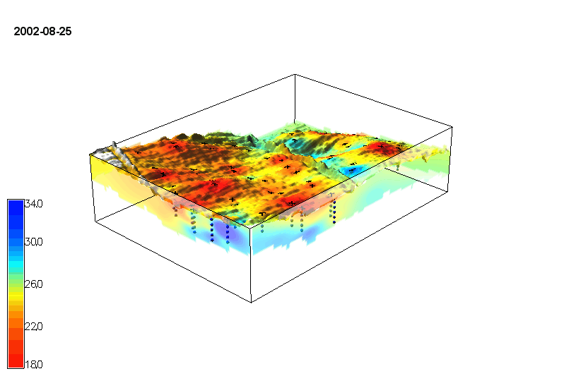
This is an animated time series of volumetric soil moisture content (TDR probes) created by Anna Petrasova. Notice how moisture content changes drastically over time. Using this type of visual technology, we can more effectively communicate with farmers, and understand how some of the soil physical characteristics vary over space and time.
After discovering a passion for geospatial analytics, my research focus has shifted to 3D and 4D spatial visualization. GRASS GIS software has the capability to model several geomorphological features, like riverbank erosion, flooding, the spread of wildfire, and depth to bedrock. The diverse visualization capabilities can provide fodder to undergraduate research mentorships in several integrated disciplines, as well as several research projects. I would like to continue to look at subsurface soil and bedrock properties, and how they impact subsurface water flow and water quality concerns. Given the broad spectrum of environmental big data, it is possible to collaborate on several professional topics within the departments of geology or biology, as well as collaborative research with other universities.
Tangible GIS
