
Problem:
ArcMap is used be several different people, and the creation of the customized toolbars can greatly speed analysis. These include customizing drop-down menus, adding layers to a context menus, and using add-in features that can be downloaded from the internet to populate features from an attribute table. This can speed up analysis time.
Analysis Procedures:
Not all of the available tools in ArcMap are found within toolbars. When running analysis, some of the tools that are frequently necessary are in separate toolbars. Creating a custom tool bar or menu can increase efficiency. This can be accomplished using the Customize dialog box. Additional tools, available for download, can add functionality to ArcMap, like the Easy Calculate tool. Once the need for customization of the ArcMap interface has been identified, one must determine what method of customization will be most useful (Fig. 1). Tool buttons can be added to active menus in the ArcMap interface. Tools can also be added to context menus, and new custom toolbars can be created. This process is as simple as opening up the Custom dialog box and dragging the new tools from the customize mode menu to their new location (after opening the context menu to be customized in the case of adding tools to a context menu). New toolbars are created within the same menu. The tools are added by dragging them to their location within the new toolbar. Tools within a customized toolbar can also be organized in a custom drop-down menu. After adding a New Menu to the custom toolbar, tools can be dragged to the custom drop-down. The add-in functions (from the internet, etc.) can be downloaded, installed, and added as buttons from the customize mode window. The Procedure-Log for this procedure.
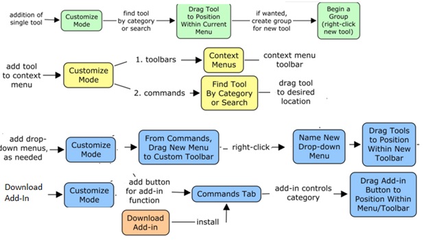
Figure 1: Flow diagram associated with customizing the ArcMap interface.
Results:

Figure 2: The new menus that are created, including the topography edits menu and the spatial statistics menu. This also shows the results of the Easy Calc add in (X and Y Center).

Figure 3: This shows the addition to the ArcMap context menu (I added Exclude Unselected Features).
Application and Reflection:
I do a lot of georeferencing and manual entry of historic contour information, to study the impact of elevation changes on soil infiltration potential and urban hydrology. Creating a menu that combines the digitizing options, selecting individual attributes, as well as some of the 3D analysis procedures allows me to save a lot of time and clicking. This can help me create land use and elevation maps much faster. Also, if my analysis are adopted as part of a larger scale model, I can save these menus into a module to share with lots of people. The skills and concepts from this exercise can be utilized in any field, but especially where non-GIS professionals may need to use ArcMap or where tasks are very repetitive. Downloaded add-in tools give ArcMap functions not possible with the stock installation.
