
Problem:
Linear files, like roads, highways, railways, or streams can contain a plethora of data that is not well suited to an x y coordinate system. Rather than break these roadways into multiple segments per attribute, this linear data, like road conditions, speed limits, or pavement materials can be stored in a linear reference file. The data can be linearly referenced using the length along the feature or distance from the origin (like highway mile markers). The objective is to try and find a correlation between road conditions and accidents for a 15 mile highway segment.
Analysis Procedure:
Linear referencing allows information about a geographic location to be stored in reference to a position (i.e. measurement) on a linear feature. Some of the data that can be collected include accident data with their associated mile marker, road quality, speed limits, etc. This permits data to be collected and used for variables that change along a linear feature. There are a number of ways to use linear referencing to answer our question on the correlation between road conditions and accidents (Fig. 1). In general, a linear feature and tabular data that describes various conditions or aspects of the linear feature are required. In our case, the starting and ending mile markers for a section of road may be listed with various attributes specific to that section of road. The tabular data can be combined with the linear feature to create a new layer that represents the tabular data on a spatial level. Multiple tables of data for the linear feature can be combined to answer more complex questions and display more complicated spatial relationships. Linear referencing utilizes dynamic segmentation to simplify geographic data storage by allowing multiple variables to be stored for a single segment/position of a linear feature. Linear-Referencing-in-ArcGIS Procedure Log.

Figure 1: Flow diagram of the linear referencing model.
Results:
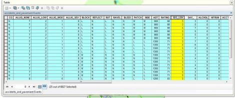
Figure 2: Selection Table for New added field added to attribute table as a float field with a precision of 6 and a scale of 2. Field calculator was used to take the absolute value of the differences between the starting and end points of each segment.
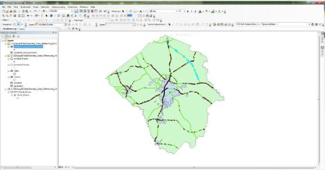
Figure 3: A clip of the Linear referenced segment used throughout this exercise.
We can use the minimum and maximum values of the Measure of the chosen route to calculate the total (15 miles). We can double check this by using the original Shape Length in feet to calculate the total mileage, as well as create a new column measuring each individual segment length, and sum them together. There are 25 total accidents in the 15 mile area. We can also look at the individual road segments and manually add up the mileage with a quality score for >75. As a result, it appears that mileage and road condition are unrelated (1.6 vs 1.7 accidents per mile) for this short segment of roads. This may change on a countywide level.
Application & Reflection:
Problem description: Linear referencing is utilized in the planning and management of highways, public transportation, railways, utilities, etc. Knowing the speed limits of roadways using linear referencing, we can use the speed limit feature to optimize our farm marketing plan.
Data needed: The marketing clusters from previous assignments, road speed.
Analysis procedures: Even though some place is further away, the speed limit may make them faster to get to. We need to calculate speed limits, and can use them in flow diagrams to determine the time to get to deliveries This can help us optimize our delivery routes and maximize our fuel efficiency.
