
Problem
North Carolina State University is a rapidly growing campus, with several new buildings and infrastructure projects planned. Since several people are involved in these facilities planning from several different backgrounds (engineers and designers that use CAD, and other stakeholders that use ArcMap), it is pertinent to develop a geodatabase of feature classes from existing CAD data and georeferenced files that management can use to make plans.
Methods:
Georeferencing a CAD file to a reference file with known coordinates, such as an aerial orthophoto, gives CAD data a spatial reference, which makes it more useful for solving GIS problems. Layers of interest in the georeferenced CAD file can also be exported to feature classes in a file geodatabase for easy organization and distribution (Fig. 1). The 1999 campus orthophoto and the georeferencing toolbar can be used to find the location of the CAD file and set it to the North Carolina 1983 State Plane. This is done by aligning two georeferencing points on the opposite end of the map (I chose a bridge on I40 and Lake Wheeler Rd, and a building by Carter Finley Stadium) to properly locate and size the CAD file. Once this is completed, use the ruler tool to measure the difference between where the CAD file lines are, and where the buildings are. If the discrepancy is larger than 30 feet, retry the georeferencing. We can export the our needed information from the CAD file data into a geodatabase. The Procedure-Log is here.
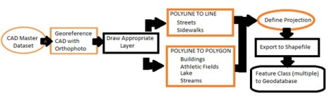
Figure 1: Generalized flow diagram of the georeferencing of the AutoCAD file.
Results:

Figure 2. CAD data of the NCSU campus after georeferencing to the reference to the 1999 aerial orthophoto (color scheme for visibility). The CAD features are aligned with the features in the photo.
Application & Reflection:
The use of Computer Aided Drafting (CAD) is commonplace in a lot of design and engineering firms that need to create 2 and 3D blueprints and landscape designs. Even though CAD is different than GIS, they have several properties in common. It is imperative that people who work with ArcMap understand how to collaborate and communicate with those who use CAD, as ArcMap can use CAD data. Studying stormwater flow over topography often involves using old CAD files, and I am very appreciative that I now know how to integrate them into my research appropriately.
Problem description: As somebody who is in the process of founding a sheep cheese dairy, we will need to hire several designers to create our new cheese making facility, farm store, and cheese aging facility. We want to make this facility as environmentally neutral as possible, meaning that most of our stormwater runoff will need to be collected on site with bioretention cells.
Data needed: The engineers would use CAD data to create our plans for the building, including elevation changes needed for the property, bioretention cell location, solar panel setups, etc.
Analysis procedures: Once the data is georeferenced, I could then convert this CAD data into shapefiles, and use the new elevation and land use (permeability changes) to evaluate the best location of bioretention cells.
